
Tropical Storm Idalia is forecast to become a hurricane when it nears western Cuba on Monday, the National Hurricane Center said, prompting Gov. Ron DeSantis to expand his earlier state-of-emergency declaration as officials across the Gulf Coast make preparations.
What was originally forecast to be nothing stronger than a tropical storm was now predicted to become a Category 3 hurricane.
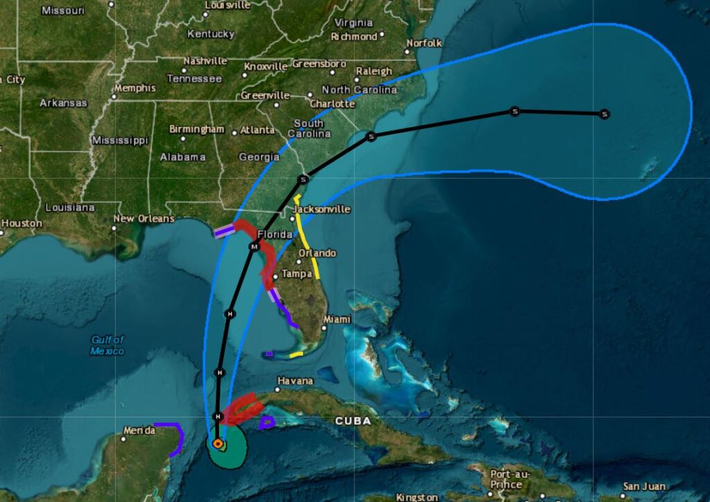
Life-threatening storm surges and dangerous winds are becoming increasingly likely for portions of Florida.
DeSantis expanded his executive order declaring a state of emergency to 46 counties, up from 33 on Saturday. In Central Florida, it now includes Seminole, Lake and Volusia counties, but not Orange or Osceola.
Those under the emergency order are: Alachua, Baker, Bay, Bradford, Calhoun, Charlotte, Citrus, Clay, Collier, Columbia, DeSoto, Dixie, Duval, Flagler, Franklin, Gadsden, Gilchrist, Gulf, Hamilton, Hardee, Hernando, Hillsborough, Lake, Jefferson, Lafayette, Lee, Leon, Levy, Liberty, Madison, Manatee, Marion, Pasco, Pinellas, Polk, Putnam, Nassau, Sarasota, Seminole, St. Johns, Sumter, Suwannee, Taylor, Union, Volusia, and Wakulla counties.
President Biden on Monday approved an emergency declaration and ordered federal assistance in responding to the storm. DeSantis had submitted a request for aid Sunday night to the White House.
Southern California heat, Tropical Storm Hilary
Heat wave to blast Southern California with 100 degree-plus temperatures
After Tropical Storm Hilary, hundreds of birds flock to the Santa Ana River
Scary landing at John Wayne Airport as jet’s landing gear collapses during Tropical Storm Hilary
Tropical Storm Hilary: Reality or hype? Weather stories covered it all
Tropical Storm Hilary: 1 missing but no confirmed deaths so far, and plenty to clean-up
At a briefing in Tallahassee, DeSantis urged all Floridians to prepare for a dangerous storm.
“We’ve got to stop focusing on the cone and look at all the areas that could be affected,” DeSantis said, noting that forecasts for Hurricane Ian kept changing and shifting further southward in the days before the storm made landfall last year, devastating the Gulf Coast. “You have time today and know what you need to do.”
The cone of uncertainty for Tropical Storm Idalia, which is forecast to become a major hurricane before it reaches Florida. (NHC)
In its 11 a.m. advisory, the NHC said Idalia has sustained winds of 65 mph with higher gusts and was located about 80 miles south-southwest of the western tip of Cuba, heading north at 8 mph. Its tropical-storm-force winds extend out 105 miles from its center.
“On the forecast track, Idalia is forecast to increase in forward speed and turn north-northeastward over the eastern Gulf of Mexico on Tuesday and reach the Gulf coast of Florida on Wednesday,” the NHC advisory said. “… Idalia is forecast to become a hurricane later today and a dangerous major hurricane over northeastern Gulf of Mexico by early Wednesday.”
It’s projected to continue north over Cuba tonight and into the southeastern Gulf of Mexico by early Tuesday.
Forecast have it growing in strength to 115 mph sustained winds with gusts up to 140 mph by 2 a.m. Wednesday parked off the coast of Florida, north of Tampa, with the projected path that has a cone of uncertainty spread from Tampa north to Tallahassee.
Already Monday, Pasco County on Florida’s west coast issued a mandatory evacuation for some residents, including those living in manufactured homes, mobile homes and RVs or in low-lying and flood-prone areas, according to the Tampa Bay Times.
Tropical Storm #Idalia Advisory 8: Storm Surge and Hurricane Warnings Issued For Portions of The West Coast of Florida. Life-Threatening Storm Surge and Dangerous Winds Becoming Increasingly Likely For Portions of Florida. https://t.co/tW4KeGe9uJ
— National Hurricane Center (@NHC_Atlantic) August 28, 2023
A hurricane warning is in place for Pinar del Rio, Cuba, as well as the middle of Longboat Key northward to the Ochlockonee River, including Tampa Bay.
A tropical storm warning is in effect for the Yucatan peninsula in Mexico from Tulum to Rio Lagartos, including Cozumel, the Isle of Youth, Cuba, and, in Florida, Dry Tortugas, Chokoloskee northward to the middle of Longboat Key and the Ochlockonee River westward to Indian Pass.
A hurricane watch is in effect from Englewood to the middle of Longboat Key and from west of the Ochlockonee River to Indian Pass. And a tropical storm watch in in place from the lower Florida Keys west of the Seven Mile Bridge to Sebastian Inlet.
A storm surge warning is also in effect from Englewood northward to the Ochlockonee River, including Tampa Bay.
Storm surge was the driving force that led to the deadly effects of last year’s Hurricane Ian that made landfall in southwest Florida.
The NHC forecasts surge could be from 7-11 feet higher than normal for Florida’s Gulf Coast from the Aucilla River near Tallahassee south to Chassahowitzka in Citrus County, from 6-9 feet higher from Chassahowitzka south to the Anclote River near Tarpon Springs, and 4-7 feet from the Anclote River south to Longboat Key.
Smaller storm surge is expected further south in Southwest Florida and the Florida Keys as well as farther north and west along the Florida Panhandle.
“The combination of a dangerous storm surge and the tide will cause normally dry areas near the coast to be flooded by rising waters moving inland from the shoreline,” according to the forecast.
Unlike Ian, the storm is expected to move quicker over the state, but rainfall totals could still bring 4-8 inches with some areas with as much as 12 inches across ports of Florida’s west coast and the Florida Panhandle as well as southeast Georgia and the eastern Carolinas that could lead to urban and flash flooding.
John Pendergrast, forecaster with the National Weather Service in Melbourne, said Central Florida will start to feel Tropical Storm Idalia’s effects on Tuesday and Wednesday.
“For Central Florida, that means that we’re going to have a threat of some heavy rain, squall conditions, so when we say that, gusts with possibly the tropical storm force of 35 to 45 miles per hour and squalls, especially on Wednesday,” Pendergrast said.
Pendergrast said the region also may face the possibility of tornadoes.
“When we’ve had similar systems pass west of the area we had tornadoes at times occur in Central Florida,” Pendergrast said.
Central Florida residents should start making hurricane preparations and secure loose items outside of their homes and prepare for possible local floods, he said.
He agreed that residents should remain vigilant and understand that the track and intensity of the storm could change at any moment.
“Small deviations on the track could bring higher effects to the area so we’re not … firmly set on the track for the hurricane yet or the intensity,” Pendergrast said.
Related Articles
Heat wave to blast Southern California with 100 degree-plus temperatures
After Tropical Storm Hilary, hundreds of birds flock to the Santa Ana River
Here’s where California’s power grid is most at risk for high winds and fire threat
Scary landing at John Wayne Airport as jet’s landing gear collapses during Tropical Storm Hilary
Theme parks blame ‘extreme weather’ for attendance drops and financial loses
Recent Comments