
Southern California residents were living with cooler but dry conditions Monday, but forecasters warned that a strong storm system is making its way toward the region that could trigger flooding and debris flows, particularly in recent burn areas.
It was a beautiful winter day in Los Angeles on Monday, Feb. 10, 2025, in this view from the Disney Concert Hall looking up Grand Avenue. The weather will make a turn by Wednesday with an atmospheric river of rain expected throughout Southern California. (Photo by David Crane, Los Angeles Daily News/SCNG)
Rainy conditions are expected to begin sometime Wednesday, and the National Weather Service has already issued a flash flood watch that will be in effect from Thursday afternoon through late Thursday night for the bulk of the Los Angeles area.
Forecasters said excessive rainfall could lead to flash flooding and debris flows in recent burn scars, including the Eaton and Palisades fires.
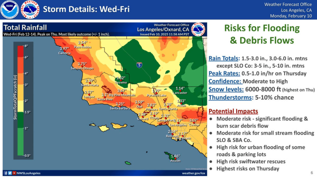
“This storm will very likely be the biggest precipitation producer so far this season for most of southwest California,” according to the National Weather Service.
Clouds are expected to cover most of the region starting Wednesday, with as much as a half-inch of rain possible. But the brunt of the storm will arrive Thursday, with widespread rain likely to impact the area for about 36 hours.
“The more dangerous portion of the storm will occur with the cold front which will sweep into San Luis Obispo County late Thursday afternoon,” according to the NWS. “It will move into Santa Barbara County Thursday evening and then Ventura/Los Angeles counties after midnight. This will be the worrisome portion of the storm as rainfall rates near 1 inch per hour will be possible just ahead and with the front. People in or near to recent burn areas will need to by hyper vigilant of weather conditions during this time frame. There is also a 10 percent chance of thunderstorms with the front which will be well capable of producing dangerous rain rates in excess of 1 inch per hour as well a gusty winds and/or waterspouts.”
Related Articles
Fast moving storms leaves fluffy piles of snow across New England
Rain falls across Southern California, with wildfire burn areas prepped for debris flow
Another storm with widespread rain and gusty winds to hit Southern California next week
Here’s how much better weather prediction has gotten recently
Trump’s claims about California water and L.A. fires are inaccurate and misleading, experts say
The rain will turn to showers on Friday, decreasing that afternoon.
Forecasters said the storm overall could drop 1.5 to 3 inches across much of the region, with 3 to 6 inches in the coastal foothills and mountains.
Snow levels will be at about 5,000 feet Wednesday, rising to 7,000 feet Thursday then falling back to about 5,000 feet. Higher elevations could see “several feet” of snow.
High temperatures will be in the 50s each day of the storm, which is about 5 to 10 degrees below normal, according to the NWS.
Graphic courtesy of the National Weather Service