Are you ready for fire season? This year’s has begun, with the Coastal fire destroying at least 20 homes this month in Laguna Niguel. Here’s a look at preparations you can take, the areas of greatest threat in Southern California and how often wildfires occur.
During the Coastal fire, about 800 households were given roughly one hour to evacuate. Take precautions now.
To better understand the needs of first responders and other emergency workers, the 2017 American Housing Survey asked residents how prepared they are for disasters.
Check your danger level
RiskFactor.com is a free online tool created by the nonprofit First Street Foundation that enables Americans to learn their property’s risk from environmental threats such as flooding and wildfires and understand how risks are shifting because of a changing environment. You can input your address or city to see the risk forecast for your property over the next 30 years.
Fire threatens a home in three ways:
Embers
These bits of burning material can move up to a mile ahead of a wildfire in windy conditions. To resist them, a residence should have a sound roof and no flammable material within 5 feet of its exterior. In the Coastal fire, embers carried by 30 mph winds ignited homes that were destroyed.
Radiant heat
A nearby fire can heat the surface of building materials to a point where combustion occurs.
Flame impingement
Transfer of heat by direct flame exposure.
Home safety checklist
Clean roofs and gutters of dead leaves, debris and pine needles that embers could set afire.
Replace or repair loose or missing shingles or roof tiles to prevent ember penetration.
Enclose under-eave and soffit vents, or screen with metal mesh to block embers. Most homes are built using 1/4-inch mesh screens, which prevent birds and rodents from entering through vent openings. Unfortunately, embers can penetrate this mesh. Smaller, 1/16-inch mesh screens can easily become plugged with dust, paint or dead plants, impeding vents’ ability to reduce moisture and temperature in the structure. Covering vents with 1/8-inch, noncombustible, corrosion-resistant metal mesh screens offers the best wildfire protection while allowing vents to function.
Repair or replace damaged or loose window screens and any broken windows.
Screen or box in areas below patios and decks with wire mesh to prevent debris and combustible materials from accumulating.
Move flammable material away from your home’s exterior.
Remove anything stored underneath decks or porches.
Armoring a home against fire
Use fire-resistant building materials.
The roof and exterior of your home should be constructed of noncombustible or fire-resistant materials such as tile, slate, sheet iron, aluminum, brick or stone.
Treat wood siding, cedar shakes, exterior wood paneling and other highly combustible materials with fire-retardant chemicals.
A few safety skills
Learn to use a fire extinguisher.
Know how to shut off utilities.
Gas: If you smell gas or hear a blowing or hissing noise, open a window and get everyone out quickly. Turn off the gas using the outside main valve, if you can, and get well clear of the home before calling the gas company. When it’s safe for you to return, a qualified professional must turn the gas back on; never attempt to do this yourself.
Water: Water quickly becomes a precious resource after disasters. All household members must know how to shut off the water at the main house valve.
Electricity: Locate your electrical circuit box. For your safety, always shut off all the individual circuits before switching off the main circuit.
Extreme danger areas
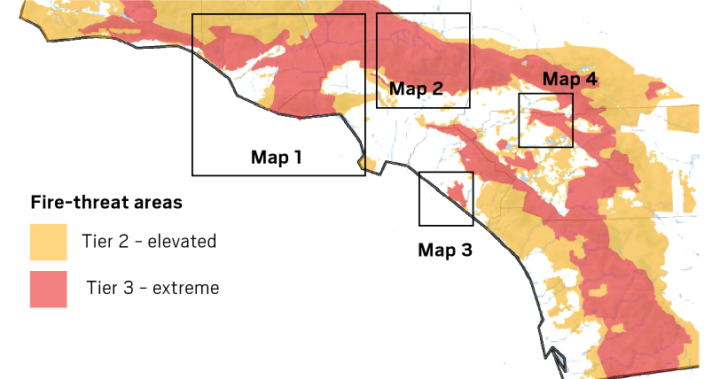
These are the state Public Utilities Commission’s Southern California fire threat maps for 2021, accounting for key wildfire factors of terrain and fuel.
You can visit the state fire marshal’s website at osfm.fire.ca.gov to see the whole state and each county.
Sources: California Public Utilities Commission, Satellite images from Google Earth, Cleveland National Forest, InciWeb, ArcGIS, U.S. Forest Service, Cal Fire, Federal Emergency Management Agency, Census Bureau
